HEC-RTS: USACE’s System for Real-Time Water Management Forecasting
The U.S. Army Corps of Engineers (USACE) is responsible for the nation’s largest portfolio of federal dams and reservoirs, operating more than 700 water control structures across the country. These sites support flood risk reduction, water supply, navigation, and emergency response – functions that depend on timely, data-driven operational decisions.
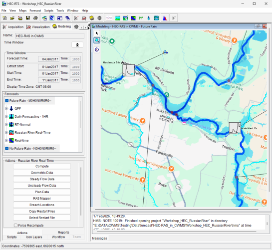
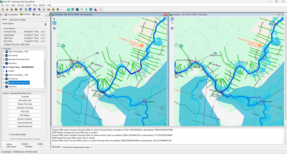
To manage this system, USACE district offices must continuously collect and validate monitoring data and run multiple hydrologic and hydraulic models under time-sensitive conditions. As data volumes increased and modeling requirements expanded, USACE has developed the Corps Water Management System (CWMS) as an enterprise software system to support data acquisition, data validation/transformation, real-time numerical modeling, and reporting. Within CWMS, HEC-RTS provides the framework for forecast modeling including meteorologic data processing, watershed runoff, reservoir operations, river hydraulics, and flood damage assessment.
A system to meet the needs of a nation
Drawing upon more than 50 years of expertise in numerical modeling and software development for water resource management and environmental stewardship, our team, through its subsidiary Resource Management Associates (RMA), has served as the primary developer of the Hydrologic Engineering Center – Real-Time Simulation (HEC-RTS), the next-generation platform for forecast operations within USACE since its inception.
Recognizing the need for a more flexible and cohesive forecasting environment that could unify modeling workflows, streamline data processing, and provide reliable decision support across districts without adding complexity for users, HEC-RTS was designed to bring together USACE core modeling tools within a single, extendable framework.
Developed as a Java-based desktop application using HEC’s engineering libraries, the platform is based on a modular architecture that facilitates interaction with standard modeling applications while also offering the flexibility to add custom computational tools.
Key components include:
- Unified modeling environment: Direct integration of HEC-MetVue, HEC-HMS, HEC-ResSim, HEC-RAS, and HEC-FIA within a single interface
- Automated data workflows: Streamlined ingestion, QA/QC, and data posting using HEC-DSS, Oracle databases, CDA APIs, Cumulus meteorological data, and Kisters WISKI systems
- Geospatial visualization: Integrated mapping with live coordinate transformation and support for GIS layers and online map services
- Ensemble and scenario analysis: Compute capabilities to support Forecast-Informed Reservoir Operations (FIRO) and other scenario-based evaluations
- Collaborative tools: Forecast dashboard and team modeling features that promote consistent workflows and coordination across district offices
- Reporting and visualization: Built-in plotting and reporting tools for efficient interpretation and communication of model results
The system was delivered with full lifecycle support – including requirements definition, system design, implementation, testing, training, and ongoing maintenance – ensuring effective adoption and continuous refinement.
Informed and coordinated decision-making
HEC-RTS is now USACE’s primary platform for real-time forecast simulation, supporting daily operational decisions across USACE districts. It provides a consistent framework for managing reservoir operations, evaluating flood risk, and coordinating emergency response.
The platform enables USACE to:
- Reduce the time required to move from data collection to actionable forecasts
- Apply consistent modeling workflows across geographically distributed offices
- Integrate hydrologic and hydraulic models within a single operational environment
- Improve visibility of model inputs and outputs through integrated mapping and reporting
- Adapt to new data sources and modeling needs through a modular, extendable architecture
By consolidating data, models, and workflows into a unified system, HEC-RTS establishes a scalable approach to water management – supporting informed, coordinated decision-making across USACE’s national infrastructure portfolio.
Key Challenges
For the U.S. Army Corps of Engineers (USACE), real‑time water management is mission‑critical. Every day, district offices must ingest large amounts of new monitoring data, verify its accuracy, and run complex hydrologic, hydraulic, and reservoir models to support operational decisions. The Hydrologic Engineering Center – Real‑Time Simulation (HEC‑RTS) was designed to bring these capabilities together, but expanding modeling needs, new data sources, and evolving operational demands required a more advanced, more flexible, and more intuitive forecasting interface.
USACE needed a modern platform that could:
- Seamlessly support real‑time data QA/QC
- Integrate multiple modeling applications
- Deliver fast, reliable forecast simulations
- Support consistent workflows across districts nationwide
This system needed to be powerful, extensible, and easy to use—built for both modeling experts and on-the-ground decision‑makers.