State of Maine Living Shorelines Pilot Project
How do you stabilize an eroding shoreline without accelerating erosion elsewhere, cutting off the supply of sediment, or disrupting the habitat the shoreline supports?
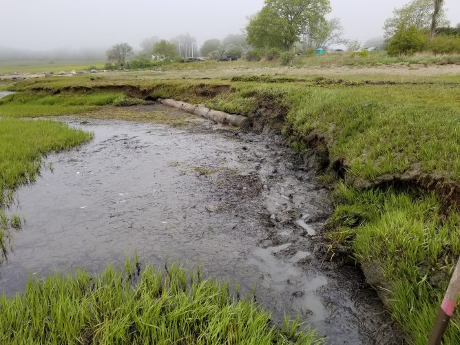
This question is central to shoreline management in Maine, where approximately 40% of the coastline consists of unconsolidated, erodible bluffs exposed to wave action, storms, and seasonal ice. Conventional approaches – such as the installation of riprap and seawalls – are designed to hold the shoreline in place, but these structures often alter sediment transport, increase erosion on adjacent properties, and contribute to the long-term loss of marshes and mudflats.
In partnership with the State of Maine’s Department of Marine Resources, Maine Geological Survey, Casco Bay Estuary Partnership, and partner agencies, GEI was engaged as lead engineering consultant to demonstrate a sustainable and scalable approach: living shoreline treatments intended to be transferable to other erosion-prone waterfronts in Maine, whether a marsh edge or a coastal bluff.
Rather than relying on fixed barriers, living shorelines are dynamic stabilization systems that maintain the continuity of the natural land-water interface. They are designed to reduce erosion while providing habitat value and enhancing resilience. On-site or locally sourced materials are prioritized, incorporating vegetation or other natural “soft” elements that may be combined with harder shoreline structures (such as oyster reefs or rock sills) for added stability.
Funded by the National Oceanic and Atmospheric Administration (NOAA), the project is part of an initiative across five states (Connecticut, Rhode Island, Massachusetts, New Hampshire, and Maine) to develop regional and state-level monitoring protocols for living shorelines across New England.
Site-specific and scalable
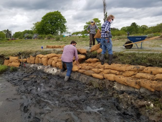
Working closely with project partners, GEI was responsible for developing and implementing low-cost and effective living shoreline designs that could be constructed, permitted, and rigorously evaluated.
Three demonstration sites in Casco Bay were selected to represent a range of shoreline conditions and erosion impacts. Each site includes an approximately 50-foot treatment reach paired with a minimum 50-foot control section, enabling direct comparison of shoreline response over time.
- An eroding marsh located on property owned by the Maine Department of Inland Fisheries and Wildlife in the Town of Brunswick, on upper Maquoit Bay adjacent to the Wharton Point Boat Launch.
- An eroding marsh located on the Maquoit Bay Conservation Lands located on western Maquoit Bay.
- A highly unstable coastal bluff located on Lane’s Island: an undeveloped, conserved island in the Town of Yarmouth near the mouth of the Royal River.
Construction of the three sites was completed in 2020, followed by a three-year monitoring program to:
- evaluate the efficacy of the installations in curtailing erosion
- identify impact on surrounding habitats
- assess survivability under Maine’s winter ice conditions, and
- compare synthetic versus biodegradable approaches at the two marsh sites.
Achieving stability by working with change
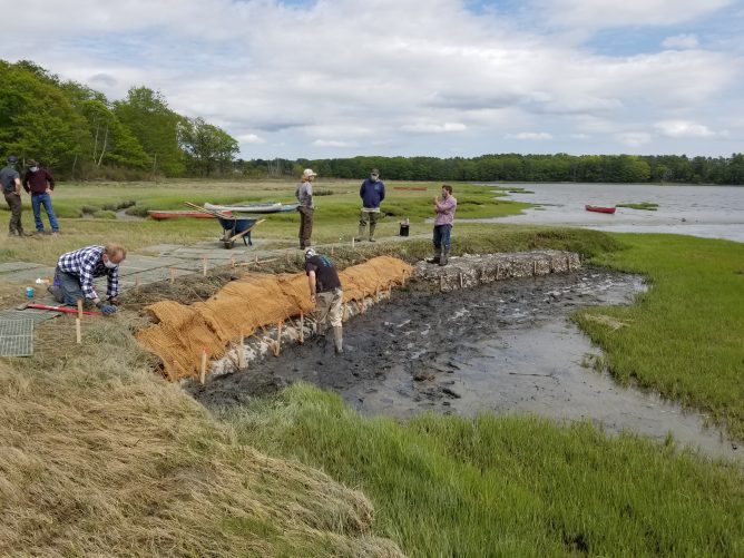
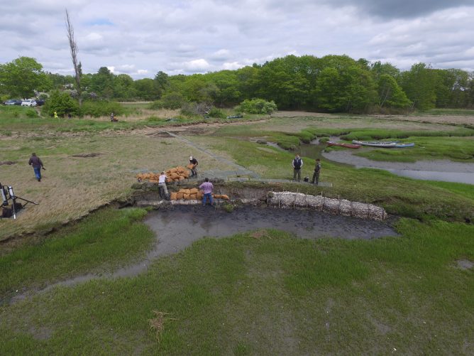
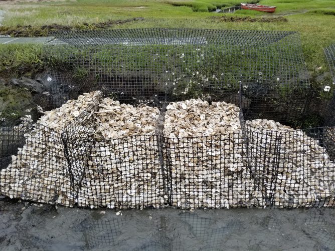
At Wharton Point and Maquoit Bay Conservation Lands, GEI developed hybrid stabilization systems using recycled oyster shells contained in biodegradable coir fabric bags and synthetic geotextile baskets (GeoReef). At each site, the installations were divided approximately 50/50 between these systems and placed below the highest annual tide to enable direct comparison.
At Lane’s Island, the bluff face was regraded to a slope and reinforced with a terraced crib structure constructed from wood available on-site. Sediment generated during regrading was reused within the terraces and placed at the toe above the highest annual tide. The installation was planted with salt-tolerant vegetation to support long-term stabilization and reduce surface erosion.
GEI led regulatory coordination, translating nature-based stabilization concepts into permit-ready designs within a framework oriented toward conventional shoreline armoring. The team also provided oversight throughout the construction process, managing logistics, material preparation, and installation sequencing, and coordinating work around tidal cycles and site access disruption.
Evaluating performance to inform statewide strategies
GEI performed three years of monitoring to evaluate relative performance across the three sites.
Building upon data collection methods initiated during site characterization, monitoring included repeat GPS surveys, erosion measurements, vegetation and elevation transects, and time-lapse photography to document tidal influence, storm response, and bluff failure processes. These results were analyzed to assess the efficacy and strategic combination of selected materials and techniques, identifying the impact on the topography, installation durability and maintenance requirements, habitat response, and ecological adaptation.
The results of the pilot program are being applied by state agencies and project partners to refine monitoring protocols, inform regulatory review, and support the development of technical guidance and decision-support tools for living shoreline implementation throughout the state of Maine.
Outcomes and long-term impact
- Established design approaches for living shorelines across marsh and bluff environments
- Defined permitting pathways for nature-based shoreline stabilization in Maine
- Demonstrated constructability using local and recycled materials, including oyster shell and natural debris
- Implemented a multi-year monitoring program to quantify performance under tidal, storm, and ice conditions
- Enabled direct comparison of biodegradable and synthetic systems under identical site conditions
- Produced data and methodologies supporting statewide guidance and decision-making tools
- Delivered a replicable framework now informing how similar projects are evaluated, designed, and advanced across Maine.